


Emilio Spedicato
Formerly University of Bergamo
With contributions by Stuart Harris
Release October 2023
1. Introduction
In part I of this work devoted to Babel Tower we derived its elevation, at 166.5 meters, exactly 20 meters higher than the Great Pyramid of Cheops. We started from a statement in the book Jacult, quoted by Voltaire in his Philosophic Dictionary, where a large number was decrypted by division by 180, a procedure that this author, Spedicato (2015), has shown should be applied to many numbers appearing in ancient traditions.
In part II first we propose a new identification of the land called Shinar in the Genesis text referring to the Tower; then we give a more detailed proposal for the place within Shinar where the Tower was built. We give an explanation of why the Tower was not completed, within the VAHS scenario, see below, and why no traces of the Tower are expected to be found, except for some bricks, some of which already re-used in local buildings. From Google Earth photographs analyzed by Stuart Harris we possibly identify the exact location where the Tower was built, within a structure typical of the third millennium BC, a so called castelliere. We briefly discuss when the Tower was built and by whom, a topic that needs further research, and that may lead to the solution of a long-standing historical enigma, say where Agade, the capital city of the Akkadian empire, was built, of which no traces have been found till now.
In this paper we will assume the validity of the following statements, albeit their validity is not necessary for the proposed identification, see their discussion in Spedicato (2023, 2004):
- Planets Mercury, Venus and Mars were not in their present orbit at the time considered this paper; they moved in elliptical orbits that took them periodically close to Earth.
- The Garden of Eden, Gan in Genesis or Kharsag in Sumerian-Akkadian texts, was located in the Hunza valley, presently Pakistan, formerly part of greater Kashmir.
- The Noachian Flood took place in the year 3161 BC; Noah built the Ark on lake Manasarovar, close to mount Kailash and to the sources of rivers Indus (locally called Senge, say river of the Lion) and Sutlej.
- The Septuagint chronology is used, differing by centuries from the much later Masoretic chronology, see La Bible d’Alexandrie, Harl (1994).
- The recently translated Samaritan text is also used, being even older than Septuagint, see Tsedaka (2013).
2. Some data on Tower of Babel in Genesis
The story of the Tower of Babel appears in Genesis in some lines whose interpretation is difficult, even for those who deem the Bible to be an essentially historical text (for many it is essentially an allegorical text, if not a collection of invented stories). Here the Samaritan text as translated by Tsedaka.
And the whole Earth was the same language and the same talk,
And it came about as the journeyed from the east
And they found a prairie in the land of Shinneeyyar and dwelt there.
And they said Go to, let us build for ourselves a city,
And a tower whose top will reach into heavens.
And Shehmaa came down to see the city and the tower which the sons of Adam had built.
And Shehmaa said: Behold, they are one people, and they all have the same language. And this is what they began to do, and now nothing which they will join together to do will be impossible for them.
Come, let Us go down, and there confuse their lips, that nobody will understand another’s speech.
And Shehmaa scattered them abroad from there over the face of the whole earth. And they stopped to build the city and the tower.
Therefore its name was called Baabel, because there Shehmaa confused the language of the whole earth. And from there Shehmaa scattered them abroad over the face of the whole earth.
The Samaritan bible translated by Tsedaka has two columns sidewise in each page, on the left the one with the Samaritan text, on the right the one with the Masoretic text. There are about 6000 variants between the two texts in the whole Torah. About Tower of Babel the Masoretic text differs as follows:
- as they journeyed east they found a plain in the land of Shinar
- Adonai instead of Shehmaa
The Septuagint text, see La Bible d’Alexandrie, Harl (1994), our translation into English, reads:
- While moving from the east they found a plain in the land of Sennaar and settled there
- This is why the name of the town was Confusion, since the Lord on that occasion confused the lips of everyone, dispersing people from there into the whole earth.
Additional material on Tower of Babel (later just quoted as Tower) appears related to Peleg, as named in the Masoretic, or Faalag, as named in the Samaritan. Peleg is one of the post-diluvian patriarchs, recalled especially because at his time the earth was divided… a fact interpreted usually as due to separation of people who became unable to speak one single language. The passage in Genesis 10-25 states, Masoretic text:
And unto Eber were born two sons; the name of the one was Peleg; for in his days was the earth divided; and his brother’s name was Joktan.
If Peleg was named so because of division of Earth into areas with different languages, an event said to happen when construction of the Tower and the associated city was stopped, then the list of post-diluvian patriarchs with their dates of birth and death provides a time estimate for the Tower story. Below is such a list, all dates from before Christ. The list is taken from Septuagint, differences existing with the Masoretic, Septuagint preferred for several reasons, including an agreement with the Mesoamerican chronologies in Ixtilhochitl, see Spedicato (2014):
- first number date of birth
- second number name of the person
- third number age of the person when he fathered the following person
- fourth number age at death
The list starts with Arphaxad, said to be born 2 years after Flood (at 3161), from Sem who was 100 at that time (died at 600 years).
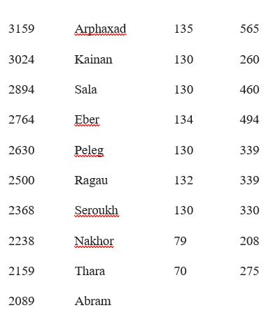
From the above we see that if Peleg was so named because of the Tower event with people dispersing, then this event should be set around his birth date, 2630, possibly a few years before. We are in the middle of the third millennium, a time of megalithic constructions and development of bronze technology. A time when:
- in Mediterranean flourished the Cycladea civilization, the Cretan one was starting
- in northern Europe the megalithic civilization was building great monuments, based upon the special measure units called remen, royal cubit, yard… that we have seen in part I of this work as incorporated into the Babel Tower
- in Egypt was time of the third dynasty. At the birth of Peleg pharaoh Djoser, estimated reign between 2700 to 2630, was possibly still living and was informed of the fate of the Tower. Djoser is especially known as the builder of the great Sakkara step pyramid, one of many monuments in the Sakkara area. The pyramid has a rectangular basis of 140 by 118 meters, elevation 60 meters (numbers without an obvious astronomic reference); on its top if Pincherle (2000) is correct, the so-called Zed tower existed, giving to the pyramid a total elevation quite possibly similar to that, 166.5 meters, of the Babel Tower. The Sakkara pyramid is often considered as the most ancient of the Egyptian pyramids. There is however evidence that the Great Pyramid, usually attributed to Cheops, might predate the Flood, albeit if originally build as a truncated pyramid, and only completed by Cheops; a date of 3441 has been obtained in 2020 by radiocarbon analysis at Aberdeen University of a piece of cedar wood found below the Queen chamber. A date very close to that obtained on other arguments by some authors, especially Duranti (1999), and several medieval Islamic historians, eg Al Massoudi.
A natural question is the following: did the constructors of the pyramid and the Tower know each other? Are their works somewhat related? In the apocryphal Stories of Joseph it is said that two buildings, one of stone and one of bricks, were built by descendants of Seth, third son of Adam, to keep certain documents in their interior, see Pincherle (2000). Such two buildings might have been the Sakkara pyramid and the Tower of Babel, albeit it appears difficult to consider such tradition of historical value.
- In Mesopotamia from 2900 to 2350 it was the time of many city states, followed by the Akkadian empire between 2350 and 2200, see also the last section. Among the local kings Gilgamesh is most notable, a person by some scholars considered as historically existing, by others, eg Pettinato (1992), a mythical character. For an analysis of his two travels on the search of a man who survived the Flood, called Ziusudra in Sumerian, Utnapishtim in Akkadian, see Spedicato (2001 a,b); notice that his first travel saw him pass by the place where we here position the Tower. Gilgamesh, king of Uruk, is often dated at about 2100, the end of the third dynasty of Ur, a new Sumerian dynasty in power after the fall of the Akkadian power by Guteans. But a Gilgamesh appears also as a divine king who reigned 126 years as fifth king in the first Uruk dynasty, that began after the Flood, with uncertain dating, in the interval 2900-2700, thus predating the construction of the Tower as estimated above.
- In China the third millennium is the time of the 8 special emperors of the first dynasty, whose historicity is uncertain. First of these eight is emperor Fuxi, considered in power in the period 2952 to 2836, and to whom many elements of civilization are attributed (calendar, writing, metal working, music, animal breeding….). The first three emperors were called Three Augusts, being Fuxi, Nuwa, Shennong; the other five are Huangdi, the Yellow emperor, Zhuanxu, Ku, Yao, Shun. 2205 is considered the final year of this initial dynasty, with beginning of the Xia dynasty. The length of the reigns of the August emperors is given by the great historian Qian Sima as respectively 18.000, 11.000 and 45.600 years; considering these large numbers as encrypted by multiplying by 180, as is the case for many numbers in Asia, including the height of the Tower of Babel, we obtain as real lengths of their reigns: 100 exact, 61 approximate, 253 approximate, thus a total of 414. Thus, if the construction of the Tower stopped at about 2630, birth year of Peleg, it was the time in China of emperor Shennong.
- About India, a problem is lack of purely historical works by Indian authors. The Ramayana and Mahabharata epics should be set in the fourth millennium, before the Flood, if the chronology of Kak et al (1995) is correct. The Gonandiya dynasty in Kashmir appears to start in 3083, some 80 years after the Flood, terminating in 1752. The story of this dynasty appears in the Kashmiri epics Rajatarangini, by Khalana, that unfortunately is missing much of the earlier period, information remaining only of two of the first 54 kings. See Stein (2009). The Indus-Sarasvati civilization, yet a complex field for historical and archaeological work, seems to have been well active in much of the third millennium, especially from around 2600 to its dramatic end by apparently a catastrophe, possibly the 2033 event that affected much of the ancient world, see Spedicato (2016 a,b). The people who came from east looking for a plane in Shinar might well have come from the Indus-Sarasvati area, Kashmir also included.
We have not done extensive literature search about the Tower, but we quote an interesting information from the Apocryphal Gospels, see Craveri (2014). It is stated that 606 years are to be counted from the Tower to Abram, while 531 years had passed from the Flood.
Taking the Flood at 3161 the second statement leads to year 2620, which might be the year the Tower was finally destroyed, say ten years after the confusion of language event and the birth of Peleg. The first statement leads to year 2700, that might be the year when works began, 70 years before the birth of Pelech. Curiously, if these numbers are correct, 70 years was the duration of the work, and 70 languages were then spoken by the people who dispersed having lost the ability to speak one same language, see Augustin De civitate Dei.
In next sections we will now consider:
- The land of Shinar as the upper basin of the river Indus.
- The likely place where the Tower was built, with possible archaeological evidence.
- What stopped the works at the Tower and how it was utterly destroyed.
- Nimrod as the likely builder of the Tower and Sargon the Great as the man who created an empire starting from the area where the Tower once existed.
- Relations between the Tower and Chaldeans who might have planned its construction and use for astronomical observations.
Shinar land identified
In this section we propose a new identification of Shinar land, usually set in the Middle East Mesopotamia formed by rivers Euphrates and Tigris. We set it in the Indian Mesopotamia associated to five rivers, presently Penjab, probably the biblical Punt, say the upper basin of the river Indus.
In the Jewish Encyclopedia, 1906 edition, by Hirsch and Barton, Shinar is considered a land around Babylon, thus a flat area. A possible association to Sumer land was also considered, starting from Lenormand, 1873, the Sumerian cities being built in a flat land. Our proposal differs from the quoted classical interpretations, both in terms of the type of terrain, not a flat one, and in its location related to a no less important land between rivers. We use here the Masoretic term Shinar, instead of the equivalent but differently spelled Samaritan word Shinneeyyar or the Septuagint word Sennaar.
Our geographic identification is based upon three arguments.
First argument, the Genesis text tells of an unnamed group of people, albeit descendant from Adam, at a time when men spoke a same language. They moved from east reaching the land of Shinar, where they found a plain apt to build a city and a tower. If Shinar was a flat land one would not have stressed as something successful to find such a plain. The text suggests that Shinar was a mountain region where finding a suitably large flat area for the proposed constructions was not so easy. A mountain area with the features here considered is the upper basin of Indus, say upper Penjab. Penjab means the land of five rivers, see below, as PEN relates to FIVE, see similarly in Greek Pente, in Russian Piath, in Sanskrit Panca….; also PUNT could be related to this land of five rivers.
Secondly, we can consider the etymology of Sinjar for a possible confirmation of the considered identification. Scholars, see eg the quoted Jewish Encyclopedia, have proposed several possible etymologies for Shinar. They include an equation with Sumir, Sungir, Sahar, Sangara, Geshur… and it is pointed out that Sin might equate with the name of the Moon, say Sin in several semitic languages.
Our proposal is based on a possible hybrid origin of name Shinar, from two dominant languages spoken in bordering areas of Shinar. Hybrid languages, whose origin can be related to trade between areas of different languages, are well known for border areas. See the many Turkish-Chinese names in Pamir and Tienshan in the travel book by Ella Maillart (2001); see especially the traditional name of Everest, say Gorishanta, or Gaurishanta, where GORI, GAURI mean WHITE DRESSED LADY, in Urdu and Sanskrit, while SHAN TA is in Chinese MOUNTAINS GREAT, thus giving to Gorishanta the meaning THE WHITE LADY OF THE GREAT MOUNTAINS. That name was changed to Everest about half 19th century in honor of the British officer in charge of the topographic office of India, among whose tasks there was to build resorts in the Everest area for holidays of British officers. Notice that other names existed for that mountain, eg the Chinese name Chomolungma, say Goddess mother of the world.
Notice that the upper basin of river Indus borders and includes part of Tibet, and Xinjang, areas always strongly related to China. Through Tibet, trade between India and China has existed for millennia, see Warmington (2014), passing by the Kailash area, connected to various parts of India via rivers Indus (Senge the Tibetan name, meaning Lion), Sutlej, and the not far sources of Brahamaputra and Ganges-Karnali. A trade that probably saw a development at the time proposed for the Babel Tower, that is the time of Shennong, the third great August emperor in China and the longest living. Thus it is natural to look at a hybrid origin of Shinar including Chinese, as in the following derivation:
SHI NAR = SHUI/SUI NAHR/NAHAR
In the above SHUI (as pronounced nowadays in northern China) or SUI (as pronounced in central or southern China) is WATER, while NAHR/NAHAR may be river, water, even snowfield, in several semitic languages, also indo-european ones (nahr in Urdu, neher in Hindi…)… Of course we use the present meanings, assuming that they reflect old meanings, no one knowing with certainty how meanings were 4500 years ago. If our guess is correct than Shinar might mean:
THE LAND OF RIVERS AND SNOWFIELDS
a very proper definition of the upper Indus basin, feeding the very rich of water river Indus and its tributaries, and very rich of glaciers and snowfields; see later for more historical and geographic details.
Third argument, and probably the most important one, is the existence in the central part of the upper Indus basin of languages and tribes whose name points directly to Shinar.
Shìna, accent on i as a Pakistani met on a beach told me, is one of the many languages spoken in the mountains of northern Pakistan, and especially in the region around Gilgit. The existence of this language was completely unknown to me till I did a search about Shinar. Shina, of which there are variants, belongs to the dardic family of Indo-Aryan languages; a notable feature is the presence in some words of three tones (in southern China there is a language with 18 tones…). It is spoken by over one million persons, mostly living in the Gilgit area, a few also in India at the border with Pakistan, and in Kashmir.
The language had no writing expression till some fifty years ago, a standard orthography not yet fully defined. Dardic languages are notable for their sound system and for preserving some words lost in India and Iran after the time of Vedic Sanskrit. Shina is also used in Hunza valley, where it is used when reciting poems, the very complex local language burushaski being used at colloquial level. This fact suggests an older origin of shina, the Bororo people of Hunza having arrived much later the Tower of Babel event, possibly at the time of Alexander campaign in India. Alexander army included soldiers from several areas conquered by him. The Bororo in Hunza might have been enrolled as soldiers from the Borohoro mountains in Kazakhstan, not too far from Alexandria Eschate, the northernmost city that Alexander built with his name, in Ferghana, Tagikistan, on river Syr Darya. Ferghana a very special country for natural beauty and fertility, its name meaning the Fertile Garden, the Chinese name Dayuan meaning the Great Garden…
In addition to be a language name, shina is also the name of a large tribe living mainly around Gilgit, with over one million people, in other parts of Pakistan, also in Indian Kashmir. Shin is the name of many small tribes living in that area, those living in Baltistan (the valley that brings to the great mountain K2) being also called Rom or Roma. Here we notice that Rom is the name of one of the five tzigan groups, say Rom, Sinti, Lovara, Kalderash, Romanichals. It is known that tzigans arrived in Europe in XI century from Penjab, where they were considered an inferior caste. Name Tzigan can be interpreted in our context as
TZIGAN = TZI GAN = ZIGURRAT GAN
say the people from the zigurrat at the Garden of Eden. This observation suggests that their ancestors worked at the Tower of Babel. There they acquired special knowledge (breeding horses, repairing metal objects…) that enabled them to live as they moved from place to place selling their services, until our time when their ancient skills are no more useful …
3. Some geographic and historical notes on the upper Indus basin
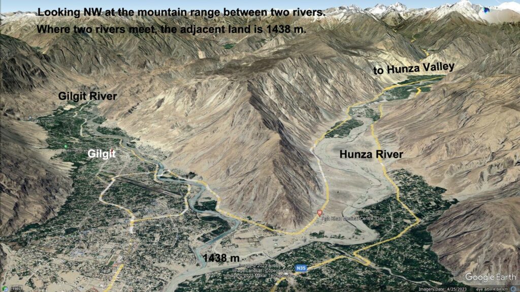
We now briefly discuss the geography and history of upper Indus basin, where Shinar land was located. In the eastern part there are the five rivers that end up in the mighty Indus river, defining Penjab proper; they are, counting from the east, Sutlej, Beas, Ravi, Chenab, Jhelum. Notice that Indus carries much more water than the Middle East Euphrates or Tigris, say maximum about 6700 cubic meter per second, against 2500 of Euphrates or 1000 of Tigris (Congo river carries up to 80.000, Amazon to 210.000). These are present values and in the past they may have been different. Notice also that once out of the mountains Indus was very wide, its width reaching up to dozens miles in time of high waters, before the river was embanked (banks of the Yellow River in some parts reach a height of a hundred meters!).
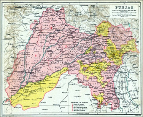
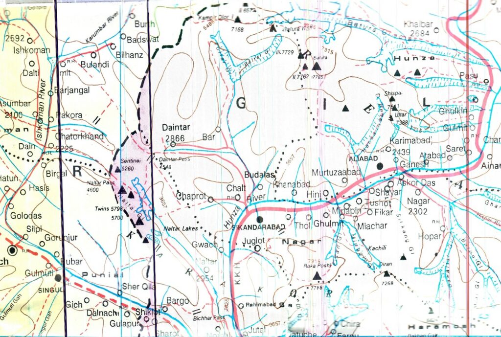
Sutlej is born, like Indus, south of the Kailash sacred mountain in Tibet, being the outflow of the two lakes, Rakshasa and Manasarovar. Sutlej valley provides a shorter passage from the Indian plain to the Kailash area than by Indus valley, but the route is rough and less used. Beas is a tributary to Sutlej. Jhelum drains much of Kashmir and passes by the town of Uri, that this author, Spedicato (1916b) has argued was the Ur where Terach, father of Abram, lived before moving to Haran, still in Kashmir, close to Srinabad, after a catastrophic event. Jhelum is a tributary of Chenab, itself a tributary of Indus. Chenab might be the river called Chobar in the book of Ezekiah, who spent time meditating on its shores. Below a map of Penjab, the upper part of rivers Kabul, Indus and Sutlej being outside of this map. Notice that Penjab is also called Panjab, Punjab.
In the western part of the Indus high basin there are the rivers Indus and Kabul. Indus has its source south of Kailash, with the Tibetan name Senge, say Lion, a meaning that we actually find again in his name in India as Sindh, and in the Indian ethnical group Sikhs. From Kailash it flows west, entering the Ladakh valley, almost parallel to the border between China and India; the valley is notable for the presence of three special words inscribed on rocks or on temple walls, read as OM MANI PANI, possibly meaning Glory to the wise man who survived the waters, see Spedicato (2023b), a reference probably to Noah who built his ark on lake Manasarovar, closed to the source of Indus, see again Spedicato (2023c). Then Indus points to south, receiving from west as tributaries first the Hunza river, then the Kabul, then from east the Chenab, the Ravi and the Sutlej.
The Hunza river, see Spedicato (2004), can be identified with one of the four rivers that in Eden are born very closely from a same source, as discussed below.
The upper mountainous basin of the Indus river comprises several political entities, whose borders have often changed in the millennia since the Tower of Babel time. Here we quote only three of such entities:
The region of mount Kailash, where Indus or Senge rivers are born, is endowed with the two lakes Rakshasa and Manasarovar, Manasarovar emptying into Rakshasa and this having Sutlej as outlet. Manasarovar at 4700 meters elevation has sources of hot water that keep unfrozen even in winter parts of its surface, one of the reasons that have led this author to propose that lake as the place where Noah built his ark. The region between Kailash and the two lakes, and the narrow land between the lakes, is rich of gold, one great mine recently discovered by the Chinese. In the past gold was excavated by a special tribe, living in deep dwellings, due to the cold and winds of the winter. Gold could also be found in the soil that marmots, very frequent in that area, threw out while excavating their dens, explaining stories in classic authors, see Spedicato (2012), about giant ants excavating gold. The region in the past was for long time part of the Zhang Zhung kingdom, its capital Khyung Lung located in the western part, near to Indian border. That kingdom was the heart of ancient Tibet. Its language, called Zhangzhung, was for a time a lingua franca in much of central Asia. A dictionary Tibetan-Zhangzhung was one of the books found in Dung Huang, published by Siegbert Hummel. The region was also one of the points in the southern Silk Road, reached from Lhasa by following the Brahamaputra, one branch going south by following the Sutlej, one going west by following Indus, crossing the kingdom of Guge, between Kailash and Ladakh. An episode that impoverished the Kailash region of monuments and documents of its past occurred when the Sikh general Golab Singh invaded the region in 1824 and destroyed its sacred places. The general had obtained power in Kashmir from the English and attacked near people to extend his power. Tibetans were able to repel it after the destructions he had made in the Kailash area. See Das (2001).
The region of Kashmir, presently divided between Pakistan and India with unsolved question about the border and occasional military confrontation, is a land often considered as the paradise of Earth. The meaning of Kashmir is uncertain: Behset, or paradise in Persian, Valley of eternal happiness, Kaspeira in Ptolemy, Sharda Peeth or Centre of Knowledge, as the secret name…. In the travel book of Baron Hügel, see Huegel (1995), who travelled to Kashmir in the first half of 19th century, it is said that Mer and Ser are the highest mountains of Kashmir. Curiously, the literature I have consulted has no references to such mountains, whose identification is proposed here:
- Mer is the great mountain now called K2, K2 deriving from the local name ketu, where ke is mountain, tu is great. It can be seen as an alternative to Kailash for possible reference to the holy Meru, being of much greater elevation, now the second highest mountain in the world, possibly in the past even the highest mountain, since that area is affected by tectonic motions that can change the relative elevations. Whether K2 has ever played a role in mythology is presently unknown to this author, but it is quite possible, perhaps its name disguised for taboo reasons… we recall that for Mongols the names of the important mountains are secret. Identifying Mer with K2 follows especially from its pyramidal shape, possibly the best of such type of geometric form among mountains. K2 is a giant pyramid of over 8600 meters height that this author was lucky luck to contemplate on his first flight to China in 1986, on a plane from Sharjia to Peking. Such beautiful pyramidal form might have inspired the Egyptian pyramids. Notice that pyramid is a Greek name, meaning having the form of flame; the Egyptian name for pyramid is in terms of consonants MR, vocalized as Mer. I section 6 we additionally consider a relation between K2 as Mer with planet Mercury.
- name Ser should relate the mountain Batura Sar, in the range Muztagh, in the north part of Hunza valley. Notice that Tagh means mountain in Turkish, Muz means probably white (see almasi, diamond as white stone, Moses, white dressed, Mzungu, white man …), so Muztagh would mean mountains white from snow… Batura may relate to AB TR, say water hard, say ice, and we note that the Batura glacier is one of the most important in the world. It appears in recent maps often as Batura II, instead of the original name Hunzakunji, whose meaning is Lord of knowledge, creator of everything, see Spedicato (2004). Sar as a variation of Ser may mean Lion, Sheher now in Urdu. The reference to lion might have come from presence on those mountains of the giant Himalayan lion that has now disappeared.
In the eastern part of present Kashmir, belonging to India, we have at least three cities of importance now and possibly even at the time of Tower of Babel. First the capital Srinagar, built by emperor Ashoka, in the third century BC, along the shores of a previous great lake that tradition says was emptied by Salomon. Near Srinagar there is one of the several monuments in Asia that recall a visit by Salomon, named Takht e Suleiman, say Throne of Solomon. According to a local tradition, see Tucci (2005), Solomon died in the Terah jungle near Kapilavastu, the place of the palace of Buddha’s family.
Close to Srinagar there is the religious city of Haràn, where the first Buddhist conference was held. It is the city where Terach Abram’s father moved after a catastrophe that devasted the city of Uri, where he was living previously, see Spedicato (2016c). Then there is Uri, on Jhelum river, notable inter alia for a sacred cedar tree forest.
The above indicates an origin of Abram family from eastern Kashmir. Notice that kashmiri language is a mix of several languages, including Sanskrit, Persian and Hebraic. Notice the existence in Kashmir of a Hebrew tribe of shepherds, the Yahudas, living in the prairies of Yusmarg. These people may descend from Nahor, one of the three sons od Terah, who remained with his father (Abram left, Haran had died in a catastrophe).
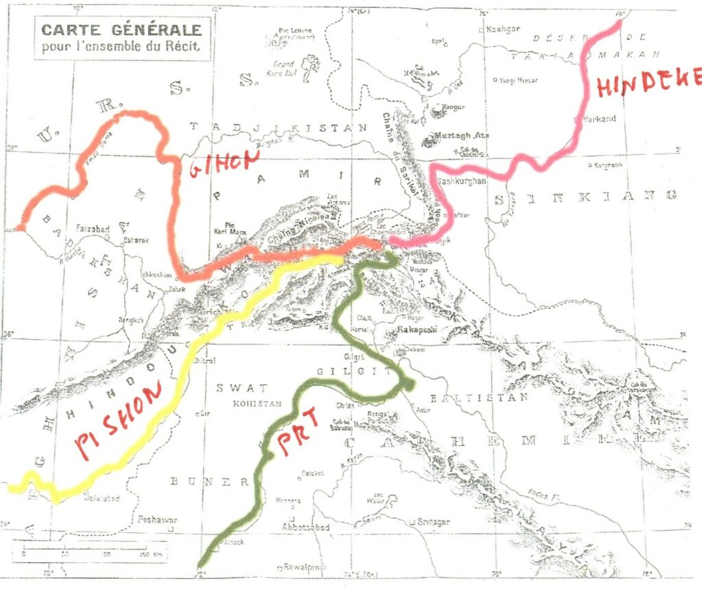
In the western part of Kashmir we find the Indus river, going south after flowing mainly from east to west, and the Hunza river, flowing in the Hunza valley in a direction almost parallel to that of Indus. Exiting from the Hunza valley, it receives the Gilgit river, continuing eastwards as Hunza and ending in the Indus. In Spedicato (2004), via analysis of Genesis and Sumerian or Akkadian texts, it is argued that middle Hunza valley can be identified with the Biblical GAN, Garden of Eden, or the Sumerian Kharsag, a name possibly meaning Terrace, from Khar = house and Sag = head. A main point in such identification is the existence of four great rivers that are born from very close sources in the northern part of the Hunza valley, say, naming such rivers in anticlockwise fashion:
- Gihon, presently Amu Darya (Water of Adam?), Oxus in Greek writers; Gihon still used in some parts of its course
- Pishon, now taking the name of cities where it passes, Yarkun, say Mastuj, Chitral, Konar, Kabul, passing by Peshawar, say City of the Border, where the root PSH is kept, ending in the Indus. The root PSH appears also in the name of the beautiful mountain Rakaposhi, that we interpret as border of the people of God
- Euphrates, or Good Fertility, or PRT, the river that irrigates the Garden of Eden and must therefore be identified with the Hunza river. Hunza a name of probable Sumerian origin, a variant of Enzu, meaning Lord of Knowledge, also called Enlil, one of the chiefs of the Anunnaki that descended in Kharsag where they created seven couples. Hunza river joins Gilgit river and then enters Indus, that can be considered from that point as the Genesis Euphrates.
- Tigris or Hindekel, now surviving as Minteke close to its source, moving north between Kunlun and Pamir with different names, ending as Tarim in the Lob Nor desert. The reference to tigers may be to that variety of feline that till not long ago was present from the shores of Caspian to China around the northern part of Tibetan massif. Recall that Foreign Minister of URSS Molotov used to spend his weekend in hunting such tigers along to Amu Darya river.
Below a map of the four rivers.
At southern end of Hunza valley the city now called Gilgit is found, about which more will be said in next section. Gilgit is famous inter alia especially as having been the main center for production of Indian hemp, called Ganji, a name where we see Gan, the Garden of Eden name in Genesis, and ji, a suffix found in Sanskrit and Indian languages, to positively stress the value of the name to which it is attached…. Gandhi was often called as Gandiji. Hemp is a very special plant, very rich in minerals and nutrients. By pressing its leaves, a drink was made called Soma or Bhang. Hemp was also used in China since fifth millennium, suggesting that already at that time a branch of the silk road was active passing probably by the Kailash area and then reaching the Gilgit via Ladakh. Gilgit was also the main center for collection of musk, the most persistent and penetrating odor, collected from the male of the deer Moschus moschiferus, hunted in the mountains NE of Gilgit. See Warmington (2014).
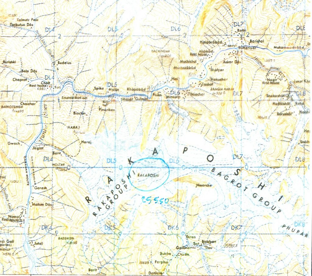
Below a map of the Gilgit province, of which Hunza is a part. Notice in the upper right part the location Baltit, capital of the valley, now name changed to Karimabad. Notice also circled by black ink the village Hini, the old name of the village Nazirabad that will be discussed below as the likely place for the Tower.
Below another map of central Hunza with some more detail, notice village Ganesh, say Ganish Khun in this paper.
West of the Hunza-Gilgit area we are in the valley of the Pishon river, that leads to the Badakshan province especially known for the Blue Mountain, the only place once known in Eurasia for lapis lazuli, the beautiful blue stone used for several purposes, including medicine, sacred rites and writings (a bronze table was found from pharaoh Menkaure time with a script in lapis lazuli). The area is still inhabited by several tribes speaking different languages and not yet fully converted to Islam. They are called Kafiri, name usually meaning infidels, but possibly derived from the Cabiri who were allied to Dionysus in his war against India, see Maraini (2001) and Spedicato (2010). That Badakshan was specially considered by Asian kings is seen in the fact that the area was never devasted by either Genghis Khan or Tamerlan. This fact allowed the preservation of the libraries of local noble families, that are kept only for family use.
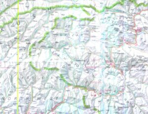
Below a map of the NE part of Pakistan, where the Karakorum highway can be seen, as well as the region of Badakshan. On the left Mastuj on river Yarkun, present name of formerly Pishon.
4. On the location of the Tower of Babel
In section above we have identified Shinar with the upper Indus basin, a vast area, some 300.000 square km. Now we restrict the location for the possible construction of the Tower to a special part of Shinar.
Our argument is that name “of Babel” for the Tower should not be considered as a special name for the tower but as the name of the location where it was constructed, as it often happens with towers, see eg Torre di Pisa o Torre di Belloluogo (a location near Lecce with a tower whose second floor contains a never studied cycle of the life of Mary Magdalene). Thus we should look for a place for which Bab El would be a proper name.
Bab means in semitic languages Gate, see eg Bab el Mandeb, the name of the passage from Red Sea to Indian Ocean, meaning Gate of Lamentations, with likely reference to the destructions brought locally by the tsunami, the Deucalion flood, produced by Phaeton explosion, 1447 BC, see Spedicato (2010). See Bab el Melech, Gate of Justice, the ancient name of the capital of Abyssinia, see Barbosa (1866). See Bab el Abwab, between Caucasus and Caspian, where a wall was built by Persian kings against incursions by Scythians. Gate means in ancient geography a place that is a necessary passage to an important region beyond, a passage difficult to manage, but usually easy to defend.
Our proposal is that Bab El is the name of the entrance point to the Garden of Eden, the Genesis Gan, the Sumerian Kharsag.
Gan and Kharsag have been identified by us, see Spedicato (2004) as the central part of the Hunza valley, presently part of Pakistan. We exclude therefore of this valley, long some 400 km, the higher part, that leads to passes close to 5000 meters as Minteke and Khunjerab, and the part that brings the Hunza river to join the Gilgit river, near present Gilgit, then to the Indus. The distance from Gilgit river junction to the Hunza central part, say the Garden of Eden in our scenario, is about seventy km, in some points the valley being very narrow, canyon-like. Passing these points in the past required people to move along almost vertical walls, or passing from one wall to the other using rope bridges, see Biddulf (2001). Passage between Gilgit and Baltit, at the beginning of Hunza central valley (now Karimabad in honor of Karim Aga Khan IV who invested much in improving conditions of life in the valley) required in the past two months, reduced to one week at end 19th century when British improved the way… now a couple of hours using the highway built by Chinese and opened in 1979.
Bab El means in our approach Entrance to the Place of El, where El has multiple possible meanings as Sky, God, Elohim… that can be well referred to Gan as a place where such high entities were considered active. Bab El should be located in the valley between Gilgit and Baltit, was available where enough space to build a great tower and a town, and closed to one of the points where the valley becomes very narrow.
That Babel be a place name is also confirmed in Genesis 10-10, where in the land of Shinar it is claimed the existence of cities Babel, Uruk, Akkad and Calneh. We can interpret this passage about Babel as the name of the town under construction together with the Tower near the gate to Gan, say the entrance to the canyon. In Cosmas Indicopleustes (1992) there is an intriguing statement about the size of the Tower, claimed to have a basis of 3 by 3 km. A size unacceptable for a tower, but that could well be the size of the town. Below we discuss Uruk and Akkad as towns in Shinar, Calneh possibly being Sarai Khola, or Gulma, in the territory of the Indus-Sarasvati civilization, just close to Shinar.
Since several years Google Earth has become a powerful instrument for studying Earth surface, via two and three-dimensional pictures, and even street pictures. Definition is quite high, I can see each tile on the roof of my house, and further improvements (already available to the military) are expected.
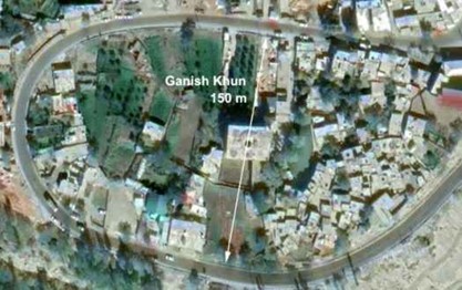
I am not an expert in working with Google Earth, but a great expert is Stuart Harris, a scholar I met a quarter of century ago in Stanford, remaining in contact since then, he visiting me a couple of times. Harris works both in catastrophic events within human memory, accepting my idea that planet Nibiru, active for some millennia with a period of 20 years, was responsible, inter alia, for the end of Atlantis and the capture of Moon; it disappeared in year 6910 in an impact onto Jupiter. Harris is specialist in dating events by sedimentation layers, and as a linguist he has proposed a reading of Old European, a language once spoken everywhere in the world, whose remnant is Finnish. I told him of my idea that Tower of Babel was located in Hunza valley. After a couple of days he sent me a note on a village in Hunza, Ganish Khun, whose name he was uncertain how to decipher, where houses, build in stones, occasionally show the use of big masonry bricks.
Ganish Khun is the oldest settlement in Hunza, about a thousand years old, and once even a place to change horses in the Silk Road (people probably arriving from Tashkurgan in Chinese Turkmenistan via Minteke or Kunjerab Pass). The name in my view derives as follows: Ganish from Gan, Khun from Turkish, as Sun, splendor, a name that we also see in the pass Khunjerab. Thus the village name may mean Splendor of the Garden of Eden… Khunjerab means The Cherub with a shining sword, recalling the Genesis pass about Adam expelled from Eden by a Cherubin armed with a flaming sword.
The bricks visible in the village walls may be bricks of the Tower that survived its destruction and were later retrieved and reused.
Below an image of Ganish Khun from Google Earth.
After this finding I asked Stuart to pursue his search for a place located near some point where the valley narrows, on the way from Hunza to Gilgit.
Da: Emilio Spedicato <emiliospedicato@gmail.com>
Date: sab 5 ago 2023 alle ore 10:52
Subject: Re: Ganish Khun, Hunza Valley
To: Stuart Harris <stuhar@gmail.com>
hunza
… you are extraordinary, the bricks might have been recovered somewhere down the river. The tower must have exploded when hit by the water from a broken lake dam high in Hunza.
For the name I propose: Ganish, as related to GAN, the Garden of Eden… Khun in Turkish is sun, you find it in the name of the Khunjerab pass where highway enters China, say SHINING CHERUB… the Cherub had a flaming sword… so for the village the name: Splendor of the Garden of Eden…
You should follow on Google map the river from Karimabad to Gilgit…there should be a stretch of this descending valley some half a mile long very very narrow, a canyon with high walls… Tower probably built near entrance from Gilgit to this canyon, on some enlargement of the valley. Then measure height over sea level at entrance and exit of the canyon, I guess it should be about the height of Tower, 166 meters… the meaning of to reach the sky would actually be to reach the level of entrance to GAN….
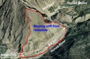
After a few days Stuart send me pictures about Nazirabad, the last town from Gilgit before Hunza. In front of Nazirabad the valley narrows, due also to rockfalls, becoming canyon-like, just before entry to Hunza. Below four pictures sent by Stuart:
- A view of Nazirabad, occupying an area more or less plain, size approximately the 3 by 3 miles given by Cosmas Indicopleustes for the Tower… the plain they searched to build a town and a tower… The road in yellow is the Karakorum Highway, from Pakistan to China over Khunjerab pass
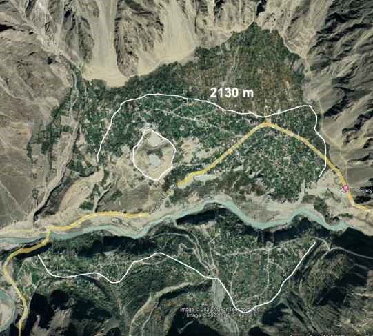
- A view of the valley between Nazirabad and Hunza, showing the difficult passage between the two places… of course we are watching the present status, how it was some 4500 years ago cannot be said presently with certainty.
- Below a centrally located mound in Nazirabab
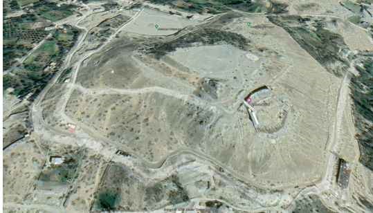
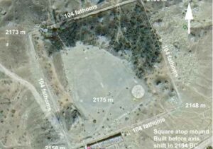
- Below an enlargement of the structure appearing in the southwestern part of the mound. It is a square with very well defined sides, measuring 104 fathoms by Google measures. One fathom is 1.8288 meters. I noticed that if correct measure of sides was 104.5, then passing from fathoms to meters, about 191, then to royal cubits, the length of the sides would be… 365.2, say a very good estimate of the number of days in a year.
- Notice moreover that in third millennium, the bronze age time, men started construction of towers enclosed in a square wall. They are called castellieri; the first ones were built in Val Camonica, Italy, then they spread elsewhere. One therefore wonders if the square shown below defines a castelliere inside which the Tower was built. Contacts between Val Camonica and India certainly existed is that inside the stomach of Oetzi, the man whose frozen body was found where ice was melting of an Alps glacier, traces were found of Helicobacter pylori, of the variety only found in India. Oetzi death is dated about 3200 BC, possibly exact date 3161, he dying under heavy snow associated to the Noachian flood.
We have found therefore by analysis of Google earth pictures:
- A town before entrance to Hunza valley, say in our interpretation before entrance to the Garden of Eden, built where the river exits from a canyon-like passage. The town name, Nazirabad, may mean, from Persian Nadir, the extraordinary place…. Notice the equivalent in Tamil as Thiruvarur, ancient capital of Tamil and place where Shiva was born (information of which I am indebted to Ravi Shah). Nazirabad is however a recent name, the old name was Hini (private communication from Ejaz Kanjudi, curator of Baltit Fort library, see below), meaning place of snow
- A square whose sides are excavated in the soil possibly being foundations of a square wall circling a space where the Tower was built. The measures of the square, a side long 365.2 royal cubits, indicate a special use for that structure.
- Inside the square on can see the faint profile of a circle, a diameter apparently somewhat over 90 meters, more precisely about 94 meters according to an email by Harris, compared to the sides of the square that measure 191 meters. The circle might be a trace of the basis of the foundations of the Tower. Now notice that 94 meters correspond to almost exactly 180 royal cubits, which suggests that the Tower diameter was very likely exactly 180 such cubits. 180 is half of 360, the number of days before the Flood, and is also the number used to encrypt certain ancient special numbers. It appears therefore that the castelliere-type structure in Nazirabad provides information about the length of the year before and after the Flood.
Another intriguing observation can be made. Ganish Khun, the oldest village in Hunza, is located at an altitude of about 2300 meters. In first part of this paper we calculated the Tower to be 166.5 meters high. If the Tower was built in present Nazirabad, its basis would be at about 2170, from the above Google Earth map. So its upper level would be quite close to the elevation of Ganish Khun…
From the above, can we interpret the statement that the Tower was meant to reach the sky, El, as actually meaning that it aimed to reach the level of a place of special importance in Gan… possibly where Ganish Khun is now located? Was it perhaps possible from the top of the Tower to see Ganish Khun, or at least parts of Gan? Was the Tower constructed when reaching Gan had become difficult due to road problems, say a closure by rockfalls?
If the above is correct one wonders how the people who about one thousand years ago constructed Ganish Khun knew where to build it, say in a special place of ancient meaning. How they knew we cannot say for certain, but we notice that Hunza lies between Badakshan and SW Tibet. Badakshan as we already observed is a place with extremely ancient libraries that survived the destructions by Genghis and Tamerlan. SW Tibet, where Zhang Zhung kingdom flourished, had many monasteries with millions of books, some extremely ancient, almost all destroyed during Cultural Revolution. We are however lucky that in Sakya monastery some 80.000 books have been recently discovered, hidden inside an external wall of the monastery. A finding that provides one order more books than those found in Qumram, Nag Hammadi and the Cairo synagogue. A trove where one might discover books also of historical meaning, not just books of religious arguments, as are most in Tibetan monasteries libraries.
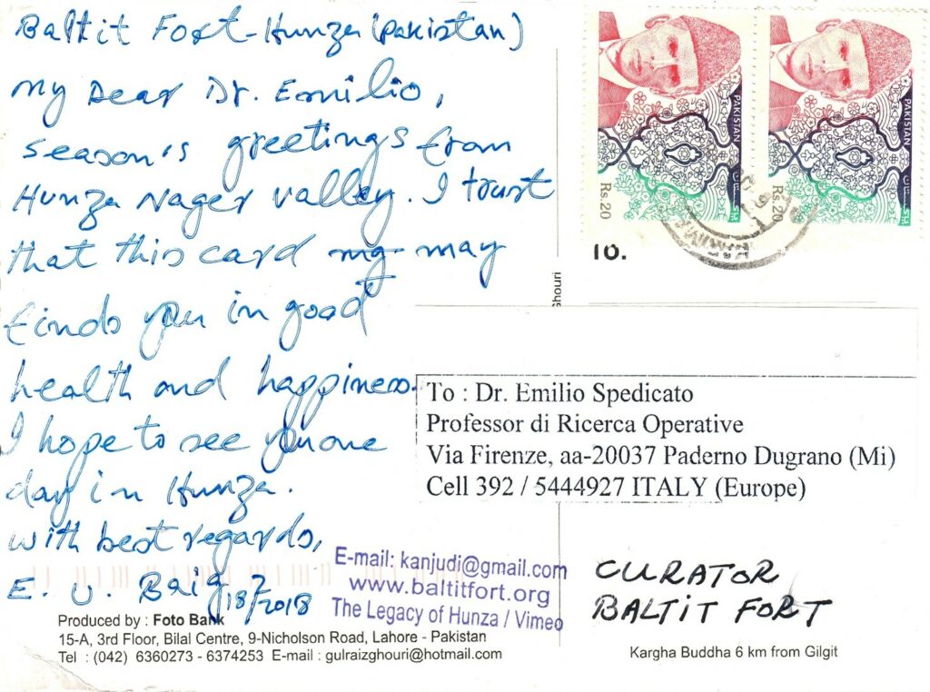
Finally, more on Nazirabad appears in the email below, received from Ejaz Kanjudi, the Librarian of the Baltit Fort Library, in Karimabad, the capital of Hunza region. I am in touch with Ejaz since the time of my papers identifying Hunza with Gan or Kharsag. A postcard by him follows this email.
Da: Kanjudi…
Date: ven 20 ott 2023 alle ore 12:41
Subject: Re: Tower Babel at (Hini aka NasirAbad – Hunza)
To: Emilio Spedicato…
Dear Prof. Emilio,
Thank you so much for sharing your milestone research and findings.
Nazirabad / NasirAbad/ Hini: Believe me you have traced my inner sixth sense voice about this location. My heart was always telling me about some very ancient human history relationship to this piece of land whenever I passed through this village.
Folk Story: Some locals of this village used to narrate that, this village was a really flat and lush green piece of land with fresh flowers, trees and water springs many centuries ago. It was known as Hayo Daas then, and a divine tribe (Haraay) was living there. That ancient tribe is said to have domesticated mountain Ibex and gathered milk and wool. In the distant past newcomers of Shin tribe from Diamer area speaking Shina killed all those early settlers. And suddenly natural disaster took place with torrential rains and floods from the mountains above, which destroyed most of that lush green settlement, which was fed with a natural spring in that time. At that time this village (settlement) was called Hayo Daas, later it was called Hini (meaning: where the snow falls during the winters because of the towering Rakaposhi / Dumani just across the river. In shina language the snow is called Hin.) )…
Respectfully yours, Ejazullah Baig
Baltit Fort Museum, Hunza (Karimabad), Pakistan
5. On the end of the Tower of Babel
Genesis states that the works for the construction of Tower and town came to a halt because God, angered at the attempt to reach the sky, ended the construction by making impossible to the workers to understand each other. They had a common language before, and lost the ability to understand it. Due to the confusion of languages, the workers dispersed and the name Babel became associated with confusion. Thus Tower of Babel appears often quoted as the Tower of Confusion.
If the above story is not just an allegory but has a basis of truth, we can explain it in terms of a natural albeit very rare event from the following considerations:
- The Tower and the city were built in a mountain region where density of population was low. Work required thousands of workers that had to be imported from other places, even quite distant.
- Mountain areas are often inhabited by people belonging to tribes each one with his own language. Even nowadays, after most world languages have been lost (African languages dropped from estimated 10.000 at beginning of 19th century to present 3000 or less) over a hundred languages are spoken in Caucasus and several hundred in New Guinea; in small Dhofar, the land producing the best incense in southern Arabia, four languages are spoken, not belonging to the Semitic or Indo-European family. Even in tiny Polynesian island Taipi, where Thor Heyerdahl spent his year of honeymoon, each valley had a tribe speaking his own language. Therefore it is likely that workers at the Tower had a different maternal languages but could communicate via a common language, learnt only at a preliminary level. The common language had to be the one of the people who coming from east had stopped where a plain was found apt to build the Tower and a city.
- It is known that different languages are memorized in different parts of the brain; and different are also the parts dealing with understanding and those dealing with speaking. It is likely that secondary languages are memorized in a less stable way than the maternal language, learnt when one is infant. It is also known that memory area of the brain can be perturbed, with even complete destruction of the content, by external actions as a strong magnetic field. One case known to this author is that of scientist Hugo Pincherle, the son of physicist Leo Pincherle, a friend and collaborator of Majorana. Hugo lost his memory after certain experiments in laboratory. Therefore we wonder if the events at the Tower, leading to stop of the work, but not to destruction of the Tower, may be explained by a natural rare fact involving a magnetic field.
We can explain the events within the context of the VAHS theory. In such scenario planets Venus and Mercury did not exist before 6910 BC (a date coming from Mesoamerican and Egyptian chronologies), when they were born from material expelled by Jupiter, hit by planet Nibiru where the Red Spot is now seen. Mercury formed probably from material from deeper Jovian regions, thereby explaining his high density and content of iron. Mars in VAHS theory before 6910 was an Earth satellite, for long years the only satellite till Moon was captured from Nibiru, of which it was a satellite, about the time of the end of Ice Age and Atlantis. Mars for 99 times (55 before Flood, at 3161, 44 after) approached Earth, every 56 years before Flood, every 54 after. Venus approached Earth every 52 years, usually coming not so close as Mars, an event especially recorded in Mesoamerica. About Mercury, it is unclear if it came near Earth at regular intervals, his close passages being less important than those by Mars, in view of his smaller mass, 3.3 10^23 grams, against 6.4 10^23. Notice the higher density of Mercury against Mars: 5.43 against 3.94, corresponding to the fact that Mercury has almost no crust, one of the standard theories claiming that the crust was lost after a giant impact billions of years ago.
A remarkable fact about Mercury is his magnetic field, hundreds of times higher than those of Mars and Venus. Measuring in microTesla, Venus and Mars have magnetic intensity less than 0.01, Mercury’s is 0.35, say over 35 times their value. A significant value, able to shift the solar wind, albeit much less than the magnetic fields of Earth, say 30, Saturn, 20, Jupiter, 430. We must add a consideration. If Mercury and Venus are relatively young planets, formed from material expelled from Jupiter year 6910, it is likely that they have not yet reached their final physical status. Venus is still very hot, as was correctly predicted by Velikovsky in his seminal work Worlds in collision, 737 Kelvin against 290 of Earth, but her temperature gets significantly lower when measured at distance of some years. Therefore it is quite possible that magnetic intensity of Mercury was higher not only when this body came out extremely hot from Jupiter, but even at the time that here we consider for the works at the Tower, say the middle third millennium, about 4500 years after Mercury formed in the Nibiru impact over Jupiter (and 4500 to now…).
From the above considerations, we propose that Mercury passed over the area where the Tower was under construction, about 2600, the time when Pelech was born. His passage increased strongly and suddenly the intensity of the local magnetic field. Such increase of the magnetic field damaged the brain memory system of the workers. They lost the ability to understand each other, while keeping their original languages. The number of tribes originating from the dispersion is given in St Augustin, De civitate Dei, as 72, corresponding also to the number of languages spoken by such people (some sources giving 70); among such tribes 19 are declared to be descendant of Sem by Al Massoudi (1877).
Quite remarkably, our hypothesis is supported by at least two statements within the classic literature.
One is from Hyginus, astronomer and librarian at the time of August, born in Alexandria 64 BC, died in Rome 17 AD. He was in Alexandria a student of Alexander Polyhistor (a very prolific writer, whose work survives only in fragments) and in Rome he directed the Palatinian library. In his book Myths he claimed that Mercury divided the nations by letting disappear the unique language that was spoken before. It is quite likely that he read the Bible in the Septuagint version, where he may have learnt of the story of loss of a unique language. But no information on Mercury as responsible of that fact appears in Bible.
Another statement is from Plutarch (2008), who states that Mercury took away one seventieth of the light of the Moon. A statement that means a passage by Mercury close to Moon and therefore also to Earth, with an interaction with Moon that moved it somewhat farther away, so that its light decreased by one seventieth. We can calculate how much the displacement was, assuming present average distance as 384.400 km and a circular orbit. Letting b the distance before displacement, we have the equation a2 = 70/69 b2, which gives b = 380.900 km, say a displacement of the Moon to an orbit 3500 km farther. To note a change of one seventieth is not a trivial matter, requiring quite accurate observations and instruments.
If Mercury passed over Babel, say Hunza valley, it is quite possible that it passed also over the giant mountain, K2, at the end of Baltistan, some 200 km away, called also Mer, as discussed in previous section. It is possible that, due to gravity action, Mercury passed exactly over that beautiful pyramidally shaped mountain. This would give a special association between K2 and the planet passing over it, whose name intriguingly turns out to be, in Latin:
MER CURIUS
where MER is the name of K2 as above shown, CURIUS can be associated to KUR (also kuru, koro, giri, guro, see Yukteswar (1993)), say mountain, providing the meaning Mercury = Mercurius = the body that passed over mountain Mer.
Another relation with K2 as MER we can be seen even in the Greek name for Mercurius, say Hermes. Noting that H can take the place of almost any consonant in the evolution of words, we observe
HERMES = MER MES = MER MS
Noting that MS is in many languages associated to the word white, we can read Hermes as (THE PLANET OF) THE WHITE MOUNTAIN MER, quite a good reference to K2.
We suspect that a hidden mythology exists about K2, kept secret, many mountains in Asia having names that are taboo (so for Mongolia).
If the above explanation for the stop of the works is correct, it is also possible that the passage of Mercury led to earthquakes, rockfalls and other catastrophic events. The area was abandoned and considered ill placed. It is possible that the Tower and the town were some years later completely obliterated by a local catastrophic event that is quite common in that mountain area (Hindukush, Karakorum, Himalaya…), say the sudden emptying of a temporary lake formed after a rockfall. For a study of such events especially in the valleys of Hunza and Gilgit river, see Hewitt (2001).
Hewitt has shown that many valleys in that area, having steep slopes, are prone to colossal rockfalls that stop the flow of the river leading to the formation of a lake behind the rockfall. One such event took place in Hunza some years ago, where a 25 km long rockfall cancelled a corresponding length of the Karakorum highway forming a lake that is still extant. Such lakes may suddenly empty when the fallen material, that acts as an unstable dam, collapses, due to earthquakes, water infiltration or other reasons. In such a case the lake loses its water in just a brief time.
There is geologic evidence that several lakes existed in Hunza just north of the canyon like point near the Bab El. If one of these lakes collapsed sometime after the Tower and the town were abandoned, then an immense amount of water, high over a hundred meters, rushed down the canyon, impacted the tower and the buildings in the town, obliterated everything from the fundaments, carrying the material, bricks and wooden pieces, down the river till joining the Gilgit river and possibly till the Indus river.
The area where Tower and town existed was scraped to the soil, possibly leaving only traces of the fundaments excavated in the rocky soil: possibly the square seen in Nazirabad, and the faint circle.
Some of the bricks may have been left in the area, pushed by the water to high places and later collected when people returned to the area, possibly at the time of Alexander the Great. They were recognized as material from the Tower and used in the construction of the modern buildings. As recalled before, some of them can be seen in the walls of houses in Ganish Khun. It would be of interest to study such bricks, and attempt their dating if organic material can be found inside them.
6. Nimrud, Sargon the Great and the never found city Agade
The previous chapters have given a geographic location for the Tower and two proposals to explain the stop of the works and the full disappearance of that huge monument, taller than the Great Pyramid. An important question not addressed is who was the builder, no answer available in Genesis, but see last section for information obtained from Newton. Extrabiblical sources claim that the builder was Nimrod, fourth in the line of descendants of Noah (Noah, Cam, Kush, Nimrod). Eber and his son Pelech, born 2630, sometime after the works at the Tower had stopped, were sixth and seventh in the line of descendants from Noah (via Sem, not Cam), see the genealogy in Section 1; the genealogy of Nimrod does not provide dates of birth and life spans, as far as this author is aware.
According to Graves and Ratai (1998) Nimrod was living at the time of Terach father of Abram and for some reason wanted to kill Abram. Since Abram was born 2089 and Nimrod was probably living when the works stopped at Tower in 2630, then he appears endowed with quite a long life. Noting moreover that according to the Book of Jasher, see Mariscal (2011), he was killed by Esau, brother of Jacob, in life at the time of Sesostris III, his life span should range from about 2700 to 1850, about a century less than the life of Adam, Noah, Methuselah… How to interpret such longevities is beyond the scope of this paper… of course the statements in the quoted texts may be wrong.
Nimrod is quoted as a great hunter and as the creator of an empire with important cities built by him, including the following:
- Ninive, not completely excavated as a Muslim sanctuary exists over part of the ruins; it was constructed over a previous town going back to 5-th millennium.
- Urfa, also called Namrud, founded by Nimrod according to Efrem the Syrian
- Gafsa, constructed by one of his officers, see El Bekri (1965), in a Tunisian oasis rich of prehistoric remains.
- Larisa or Nimrod, some 30 km south of Mosul, once a quite large city, perimeter some ten km, walls height 100 feet, width 25 feet.
While there is no certainty that the above cities were built by Nimrod, their existence west of our proposed place for Babel Tower can be taken as an indication that the constructor of the Tower, be him Nimrod or someone else, who had arrived from the east, after the failure of his enterprise, moved further west, settling in that Assyria where the great city of Assur existed at least from 2600. A time, from 2700 to 2500, where new important civilization flourished, great monuments were built (Sakkara and then completion of the Giza pyramids, the Tower…) and, if the tales about Nimrod have historical value, a first empire was realized reaching even beyond the sea, as Gafsa shows.
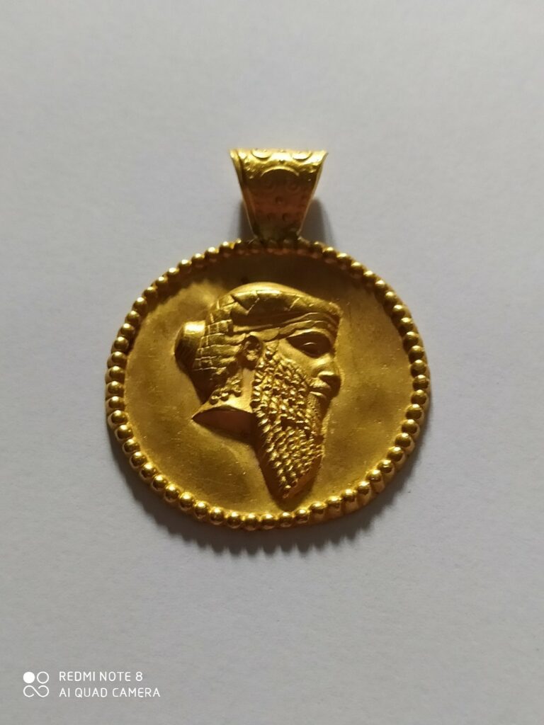
A second great king in the third millennium, whose historicity is not doubted, albeit there is discussion on dates and on several aspects of his personality and power, see Pincherle (2001), is Sargon the Great, or Sharrukin. Below his image in a golden jewel realized by Mario Pincherle and given to this author.
Sargon is deemed to have reigned 56 years, see Marin et al (2010), but it is uncertain when he was in power. Pincherle (2001) proposes a very early date, claiming he was born in 3761, say at the start of one of the Hebrew calendars (according to this author that calendar starts with Noah’s birth). In Ceram (1961) Sargon is set around 2350. Corradini (2019) gives for his reign 2419 to 2363, say 56 years. In Wikipedia dates are 2335-2279, again as reign of 56 years, and note that 56 is a number associated to Mars in the VAHS paradigm. It is deemed that the Accadian empire got maximum extension under Sargon’s nephew Naramsin, whose reign is dated at 2254-2218. The Akkadian empire, and other lands, were destroyed in 2193 by a catastrophic event with destructions from at least Oman to Northern Europe; an event therefore similar to the one that in 1447 devastated lands from at least Yemen to Scandinavia, ending inter alia the Cretan civilization and explaining the Exodus events, see Spedicato (2010). See below a mail by Harris on the 2193 catastrophe.
Venerdì 6 ott 2023 alle ore 11:43 Stuart Harris <…@gmail.com> ha scritto:
Archaeologists have recently been able to obtain an exact date for the fall of Akkad, 2193 BC, by using an offset from an eclipse.
This matches the sinking of Aldland in 2193 BC that both seared and flooded the North Atlantic and Baltic regions. All the forests in Germany caught fire, and the lowlands of Ireland, Britain, Denmark and Holland were flooded.
Afterward, Akkad ceased to exist. A king list disintegrates into unknown people who ruled for months at a time.
The Akkadian cities in the north were incinerated, leaving a thin, conformable layer of charcoal that fell vertically from above. There was no time for evacuation; building stopped with bricks ready to be laid, one of which was imprinted with Narim Sim. No skeletons or beams have been found. The type of charcoal is special, formed by evaporation at extremely high temperature in a laboratory, say 4000 degrees C, called a Flash Thermal Phenomena.
On top of the charcoal lay a thin layer of coarse dust, then a thick layer of fine dust that was up to 1 m thick in hollows. Within this fine dust were pieces of plastic formed by lightning. The fine dust and lightning came from dust storms, whose signature occurs in the Gulf of Oman as a layer of dolomite spanning 300 years, from 2200 BC to 1900 BC, dates not exact.
The dust was sterile, and remained so until 1900 BC.
300 km south, the cities of Akkad were all destroyed by a shock wave.
Source: Ancient Apocalypse: The Akkadian Empire; History documentary, 50 minutes. Stu
Sargon appears here because of the story on his infancy, and the fact that his capital, Agade or Akkad, never archaeologically found, might be set in the region of the Tower.
The first story, see for instance Leick (2006), is that he was born by a priestess, who had failed in her commitment for chastity. She put the newly born infant in a basked floating on river Euphrates. The infant was found and saved by the water seller Aqqi. Here we depart from usual interpretation. We assume, following Spedicato (2004), that Euphrates is the river of Eden called Euphrates in Genesis, presently named Hunza, thus a tributary of Indus. We do not know in which point of the river the basket was put, we guess close to where Hunza and Gilgit rivers joins, a rather flat area with river water current not too strong. We recall that the Karakorum valleys have little rain reaching their bottom, being a kind of valley deserts; moreover rivers often have their bed tens of meters below the main valley floor. A fact that leads naturally to special workers doing the hard work of going many times a day down to the river to collect water for the people. Aqqi was possibly one of such workers; the priestess should know quite well that he would be around and could save the child.
Under the above scenario Sargon, who was probably born at end on 15th century BC, grew in a land where there was strong memory of a great man, Nimrod, who had built a great tower and a town up the river Hunza. Two monuments that either still existed or more probably had already been wiped out by the sudden arrival of water from a collapsed lake dam.
How he became a powerful king with a kingdom often considered as the first multinational empire, is certainly not fully understood and is not matter for this paper. But if his origin was from the Hunza river, it is likely that he built his capital city in that area. A natural location for such a building is where rivers Hunza and Gilgit join, the place where he had been saved. Notice that river junctions in India are considered especially auspicious, being blessed by the energies from both rivers. Notice also that such a city could have a river port, being thus a commercial center for export of special products from that area, including gold, lapis lazuli, musk, and ganji, say Indian cannabis either in form of leaves or of the drink soma… After joining Gilgit river, Hunza river is much rich of water and flows in a valley that is quite open.
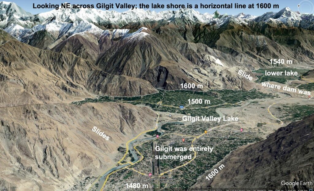
Below a vision of where valleys Hunza and Gilgit meet. Notice that after their meeting the river continues with the name Hunza, entering Indus after about 100 km.
Here we hypothesize that the name of the city build by Sargon was… Agade, a name that we see related to the local geography in the considered area:
AGADE = A GA DE = A GAN EDEN =
WATER/RIVER FROM GARDEN OF EDEN
Agade has never been found, this being one of the enigmas of assyriology as professor Giovanni Pettinato told me. Under the present scenario lack of finding Agade can be explained by two reasons:
- no one has looked for Agade where we have set it, all searches having been done in the Middle East Mesopotamia.
- Agade no more exists since it has been obliterated by a water flux similar to the one that obliterated the Tower and the nearby town.
The picture below shows how Gilgit lies over a layer of material from a similar flood.
Agade was probably reconstructed, after the death of Sargon, with another name, Sargin, that later changed into Gilgit, see Biddulf (2001). Etymologies are difficult to be established with certainty, but we can propose one for Sargon and Gilgit.
About Sargon, we see SAR as a variant of SIR, SYR, SER, SHER, SINDH, SENGE… all words meaning lion in several languages in areas close to Tibet; the reference being possibly to the now disappeared giant Himalayan lion, see Moorkroft (1937), Bernier (1991), Kalidasa (1992), possibly the mysterious huge animal called manticore in ancient traditions. To Lion one can easily associate the meaning Prince, King… Hence Sargon would mean the Prince of Gon, GAN.
About Gilgit we notice:
GILGIT = G/K L/R G/K T
The above sequence of consonants can be retrieved in words as Golgotha, Circle, Circus, Cylinder… indicating a circular structure. Also in Akkadian GLGL are the consonants for wheel, see Pincherle (2001). Additionally, KLU in Tibetan is snake, say a cylindrical being, water snakes in Tibet being sacred, snakes in India also cannot be killed, being considered endowed with some wisdom; also consider Akkadian Apkallu, adviser, from AP =, KALLU = SNAKE. Thus we propose for Gilgit the meaning
GILGIT = THE PLACE OF THE GREAT CIRCULAR (MONUMENT)
as a reference to the Tower, whose memory must have survived.
7. A relation between Tower and Chaldeans?
For the present section the author is indebted to Isaac Newton, whose master work was, according to him, see his biographer Westfall (1993), not the Principia, but the one on the emended chronology of ancient people. Reading such book is, according to Westfall, the worst penalty that can be imposed to a man… and I read it. The work was published in Latin in 1728 one year after Newton’s death. I read the English version by Pierce et al (2008), just after having written the pages before this section.
In Newton, whose knowledge of classics was monumental, I found some statements from classics (read by me many years ago but forgotten), that suggest further considerations about the Tower (quotations not verbatim).
- – From Diodorus Siculus: when Alexander entered Asia, it was estimated by the Chaldeans that they had been studying the stars since a time corresponding, as Newton calculated, to about 473.300 years BC.
- – Again from Diodorus: Chaldeans in Babylonia claimed to be just a colony of Egypt, whose knowledge of sky came from Egyptian priests.
- – From Apuleius: Pythagoras, brought from Egypt to Babylonia by Persian king Cambises, learned his science from Magi and Zoroaster. From Curtius Rufus and Ammianus Marcellinus the knowledge of Magi and Zoroaster derived from Chaldeans. Zoroaster moreover spent time in wooden wildernesses of the unknown regions of Upper India, learning from local people about movement of earth and stars.
We propose the following interpretation of the above three statements.
In the first statement the date 473.300 appears to be impossible at face value, as it often is the case with numbers in ancient traditions. We have argued, Spedicato (2015), that such numbers are encrypted, being the result of the original true number multiplied by 180, a fact that we used in Part I of this work to derive the real height of the Tower. Dividing 473.300 by 180 gives 2629,44, a number very closed to the 2300 BC that appears in Septuaginta as the birth date of Peleg, whose name was given with reference to the end of the Tower works, see first section of this paper. We would get exactly 2630 if the number in Newton was 473.400, an error being possible in the manuscripts. The fact that the decrypted number is so close to the Septuaginta date associated to the end of the Tower suggests the following:
- The Tower was at least partly used as an astronomic observatory, also before the works were fully completed.
- Chaldeans were involved in the use of the Tower and probably also in its planning and constructions.
- Since the Tower was built by unnamed people arrived from East, also Chaldeans probably had an origin from east of the Hunza river.
Chaldeans are usually considered as people living in southern part of (Middle East) Mesopotamia, where they are quoted from Assyrian documents of at least IX century BC, see Wikipedia (consulted 16-11-23). The Diodorus statement claims they were a colony from Egypt; as a guess we propose they arrived in the Babylonia region following the Egyptian king Sesonchis, or Seshonq I, amply cited by Newton who (wrongly) identifies him with Sesostris the Great. As the following argument sets the Chaldeans in the Upper Indus region, we may here conjecture that Chaldeans in Egypt also were a colony from…somewhere in the Upper Indus region. They possibly arrived to Egypt either at time of Sesostris the Great, whose military campaign took him to India, for ephemeral conquests, around 1870 BC, or at time of the war of Dionysus against India, at the time of Exodus and related catastrophes, see Spedicato (1910). When the libraries in Hercolanum will be recovered, we may find full texts of Manetho, Berosus, Hecataeus, Sanchoniatho, Nicholas of Damascus et alii, and the above questions might have a convincing answer.
The third statement claims that Zoroaster, master of Magi, got their knowledge of astronomy from Chaldeans and especially that he studied in Upper Indus in unknown regions. This statement strongly suggests that Chaldeans lived in Upper Indus, that includes the Shinar region here considered, in a place unknown, say little known as difficult to reach. One such region is Kashmir, a beautiful area as previously discussed, but certainly not easy to reach, albeit not so difficult as the Hunza valley. Kashmir is traditionally considered a land of magician, possibly a recall of the Chaldeans who lived there in antiquity and were teachers to others. Notice that at the time of Qubilai, the Khan visited by Marco Polo, the Mongols religion was a shamanism with magical rites from Tibet and Kashmir (two regions geographically and historically related), see Dockray Phillips (1979).
Kashmir lies east of where the Tower was built. Around 2300 BC Kashmir was still under kings of the great and very long lived Gonandiya dynasty, whose full story was described in the initial part of Khalana’s epic Rajatarangini, unfortunately lost. We may hypothesize the existence of a king who was rich, knew of the past, including the fact that Hunza valley was Gan or Kharsag…, and whose interest in knowledge made him willing to provide the Chaldeans with a tower useful for astronomical purposes.
We conclude with a new proposal for the etymology of word Chaldean. Pointing to the consonants we have
CHALDEAN = CH/G H L D N = KLU TA AN = snake great sacred
Recalling that Klu = snake, in Tibetan, Apkallu = advisor in Akkadian, say water snake, that water snakes are sacred in Tibet…. that snakes are considered prudent, see Gospel, and wise, and sacred in India… we propose:
CHALDEAN = the sacred great snakes, the sacred great in knowledge.
A similar derivation we can propose for the name of the Gonandya dynasty:
GON=GAN AN D=TA = the great sacred kings of the Gan, Garden of Eden… albeit no one can presently say how extended was Gonandyas domain in the third millennium BC.
8. Conclusions
In this paper we have argued for the following results:
- The land called Shinar in Genesis corresponds to the high Indus basin, especially the region where rivers Gilgit and Hunza flow.
- Babel is the name of a certain point along the river route to Hunza valley, that was biblical Gan, Garden of Eden, a point where the valley restricts becoming canyon-like.
- Inspection of Google Earth suggests that the Tower was built where is now the town of Nazirabad, once Hini, inside a walled square, whose sides measure 365.2 royal cubits.
- A faint circular trace inside the square of likely diameter of 180 royal cubits might be related to the Tower fundaments.
- Construction works were stopped after a sudden strong magnetic field, due possibly to a close passage by Mercury, damaged the brain areas associated to the acquirement of new languages.
- The construction of the Tower was possibly decided by a Kashmiri king of the Gonandiya dynasty in collaboration with Kashmiri Chaldeans.
- The Tower and the town were destroyed by a catastrophic river flood, caused by the collapse of a dam of a temporary lake formed after a rockfall.
- Bricks used in the Tower that are occasionally found may have been reused in some villages of Hunza, especially in Ganish Khun.
- King Sargon possibly built his capital Agade close to where rivers Hunza and Gilgit meet.
Acknowledgements
Author is greatly indebted to Stuart Harris for searching Hunza Valley via Google Earth, providing the images here given, and pointing to the work of Hewitt. This work would not exist without his contributions.
Bibliography
Agostino, La città di Dio, Città Nuova, Roma, 2000
Duarte Barbosa, A description of the coasts of east Africa and Malabar, Hakluyt Society, 1866
Abou Obeïd El Bekri, Description de l’Afrique Septentrionale, Jean Maisonneuve Successeur, 1965
François Bernier, Viaggio negli stati del Gran Mogol, Ibis, 1991
John Biddulph, Tribes of the Hindukush, Bhavana Books, 2001
C.W. Ceram, Il libro delle rupi, Einaudi, 1961
Sarat Chandra Das, Journey to Lhasa and Central Tibet, Classic India Publications, 2001
Gian Carlo Duranti, Da Giza-Sion-Atene per una città della scienza, Olschki, 1999
Arturo Corradini, La vera età dei patriarchi, Comunità Montana Valle Ossola, 2001
Marcello Craveri, Vangeli apocrifi, ET, 2014
Eustace Dockray Phillips, Genghiz Khan e l’impero dei Mongoli, Newton Compton, 1979
Robert Graves, Raphael Ratai, I miti ebraici, Tea, 1998
Kenneth Hewitt, Catastrophic rockslides and the geomorphology of the Hunza and Gilgit valleys, Karakoram Himalayas, Erdkunde, 55, 2001
Charles Hügel, Travels in Kashmir and Panjab, Asian educational services, 1995
Subhash Kak, Georg Feuerstein, David Frawley, In search of the cradle of civilization: new light on ancient India, Motilal Banarsidass, 1995
Kalidasa, La stirpe di Raghu, Melita, 1992
Cosmas Indicopleustes, Topografia cristiana, D’Auria, 1992
Gwendolyn Leick, Città perdute della Mesopotamia, Newton Compton, 2006
Ella Maillart, Des monts celestes aux sables rouges, Payot, 2001
Fosco Maraini, Gli ultimi pagani, BUR, 2001
Diego Marin, Ivan Minella, Erik Schievenin, Le tre età di Atlantide, i tre diluvi che distrussero la civiltà, Eremon, 2010
Andres Vazquez Mariscal, El Genesis, la verdadera historia, Eo
Larry and Marion Pierce editors, Newton revised history of ancient kingdoms, Master Books, 2008
Giovanni Pettinato, La saga di Gilgamesh, Rusconi, 1992
Mario Pincherle, La grande piramide e lo Zed, Macro Edizioni, 2000
Mario Pincherle, La vera storia di Sargon di Accadia, MIR Edizioni, 2001
Plutarco, Iside e Osiride e dialoghi delfici, Bompiani, 2008
Emilio Spedicato, Geography of Gilgamesh travels, part I: the route to the mountain of cedars, Migration and Diffusion 1,6, 100-113, 2001a
Emilio Spedicato, Geography of Gilgamesh travels, part II: the route to Mount Mashu, Migration and Diffusion 1,7, 6-18, 2001b
Emilio Spedicato, Geography and numerics of Eden, Kharsag and Paradise: Sumerian and Enochian sources versus the Genesis tale, Migration and Diffusion 5, 18, 17-41, 2004
Emilio Spedicato, Atlantide e l’Esodo, Platone e la Bibbia avevano ragione, Aracne, 2010
Emilio Spedicato, Ophir, a proposal for its location, Quaderni Asiatici 99, 103-120, 2012
Emilio Spedicato, On the Mayan chronology, MES Journal 24-25, 2014
Emilio Spedicato, Large numbers in Asian chronology decrypted, MES Journal
24-25, 68-75, 2015
Emilio Spedicato, On hypothetical model of Mankind development in astronomical scenario of Earth evolution, Problems of nonlinear analysis in engineering systems, Kazan, 1(45), 22, 64-106, 2016a on
Emilio Spedicato, The VAHS Scenario (Velikovsky, Ackerman, Harris, Spedicato) on evolution of solar system in the last three myriads, www.emiliospedicato.it, 2023
Emilio Spedicato, New astronomic hypothesis in cosmogonies of Solar System evolution, Actual problems of aviation and aerospace systems: processes, models, experiments, 2(43), 21, 1-26, 2016b
Aurel Stein ed., Kalhana, RAJATARANGINI, Motilai Publishers, 2009
Benyamin Tsedaka, The Israelite Samaritan version of the Torah, 2013
Giuseppe Tucci, Il paese delle donne dai molti mariti, Neri Pozza, 2005
E.H. Warmington, The Commerce between the Roman Empire and India, Cambridge University Press, 2014
Richard Westfall, The life of Isaac Newton, Cambridge University Press, 1993
Sri Yuktesvar, La scienza sacra, Astrolabio, 1993
Autore: Emilio Spedicato – Formerly University of Bergamo emiliospedicato@gmail.com – www.emiliospedicato.it
0 commenti